
Difficulty - Easy to Moderate


SKYTRAIL; TRANSCANADA TRAIL, OUTLOOK
The SkyTrail, which is a part of the TransCanada Trail, is located within Outlook and follows the South Saskatchewan River. The trail system is quite extensive and offers some of the best hiking in Central Saskatchewan that you can find.
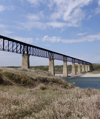
The Skyview Trail is most famous for the massive train bridge that has been converted into Canada's longest pedestrian bridge at just over a kilometer long. The bridge towers over the South Saskatchewan River Valley at 48 meters tall. However, unfortunatley the bridge is currently closed to the public and cannot be accessed. That doesn't mean that you still shouldn't venture out here as the hike around the SkyTrail is fantastic.
The trail can be used for hiking, biking, snowshoeing and cross country skiing depending on the season. It is well maintained and easy to navigate as you just need to keep the river to whatever side of you that you are walking.
Since you are following the South Saskatchewan River Valley there are many opportunities to stop and check out some amazing vistas. Make sure to climb the hills and take a break to soak in the scenery.
Woodticks can be quite bad in the long grass in early spring and summer, so check yourself after the hike. If you are a bit squeemish of ticks, remember the deer ticks that carry Lyme disease are very rare in Saskatchewan. So you'll be fine!
The trail takes you through the odd tree grove, a few streams (in the Spring) and gives you the opportunity to see a lot of wildlife if you are quiet enough. Last time I was out I startled quite a few creatures who retreated to the bush. There are a few old cottonwood relics that dot the shoreline that are a great place to stop and have a picnic.
The trail that is linked on the Hiking Map button is only 4 kilometres long but you can follow the river valley for as long as you want. I believe some more intrepid explorers have hiked all the way from Outlook to Saskatoon following the South Saskatchewan River. The last time I was out here I went about 5 kilometers north of Outlook.
Feel free to hike as far as you want and explore the valley. I would rate this as one of my more favourite trails in the province.
SaskHIker Recommendation
Head north from the base of the SkyTrail Bridge and follow the TransCanada Trail, the trail will end about 2 kilometres from the bridge but there are paths to continue hiking along. Continue north for another 3 kilmoters pass the power lines. You will find a stream, cross it and look to the right. There will be a large hill climb to the top of it and look back towards the bridge.
The view is well worth it!
Getting There
Outlook is located on Highway 15. There are many ways to get to the town, but if you are coming from Saskatoon I highly recommend taking Highway 219. The drive on this highway offers some great views of the sand dunes near the Dakota Whitecap First Nations Reservation.
Once you are in Outlook there are signs on Main Street that direct you to the trail entrance. They are quite easy to follow.


